Category 5 Hurricane Milton: Monday, Oct 7 update from the NHC on latest developments
Published 1:42 pm Monday, October 7, 2024

Article first published: Monday, Oct. 7, 2024, 4 a.m. ET
Article last updated: Monday, Oct. 7, 2024, 1 p.m. ET
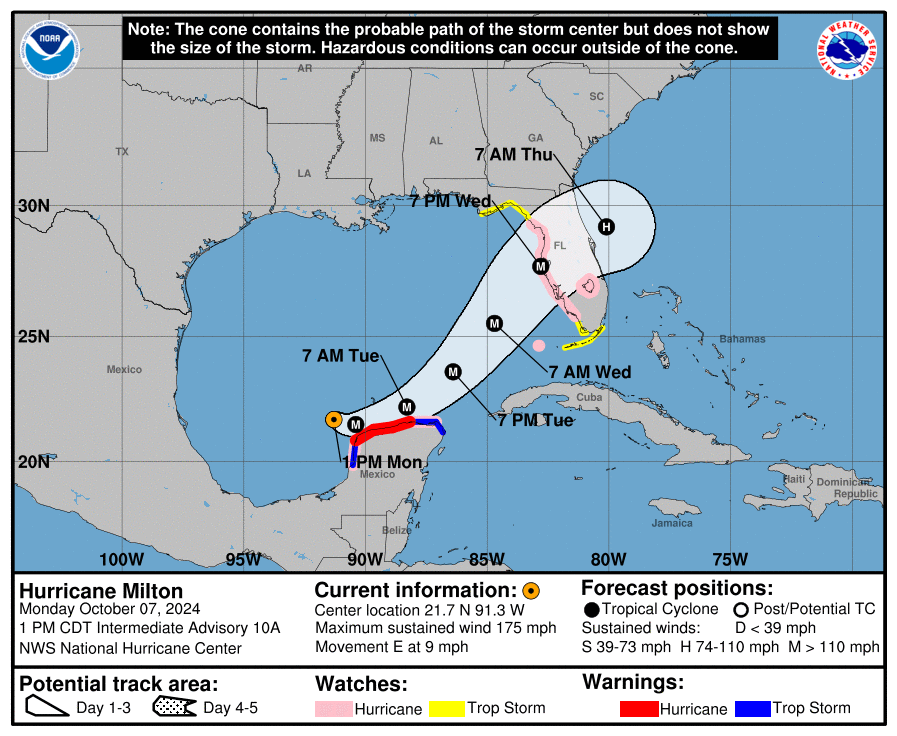
The National Hurricane Center’s 1 pm Monday advisory reported that Category 5 Hurricane Milton is 105 miles west-northwest of Progreso Mexico and 700 miles southwest of Tampa Florida, with maximum sustained wind of 175 mph. It’s moving 9 mph to the east.
“… Milton is forecast to move near or just north of the Yucatan Peninsula today and Tuesday, then cross the eastern Gulf of Mexico and approach the west coast of the Florida Peninsula by Wednesday.” according to analysts. “While fluctuations in intensity are expected, Milton is forecast to remain an extremely dangerous hurricane through landfall in Florida.”
There were numerous changes today: Milton began as a Category 2 hurricane, a Category 3 hurricane and a Category 4 hurricane but ultimately became a Category 5 hurricane with sustained winds of 175 miles per hour.
YESTERDAY (Sunday):
Yesterday, Milton reached new heights of intensity and was upgraded from a tropical storm into a Category 1 hurricane, with winds blowing at 80 miles per hour.
Forecasters issued a hurricane watch for the northern coast of Yucatan peninsula.
SUMMARY OF WATCHES AND WARNINGS IN EFFECT:
A Hurricane Warning is in effect for:
– Celestun to Rio Lagartos
A Hurricane Watch is in effect for:
– Rio Lagartos to Cabo Catoche
– Campeche to south of Celestun
– Florida Gulf coast from Chokoloskee to the mouth of the Suwanee River, including Tampa Bay
– Dry Tortugas
– Lake Okeechobee
A Storm Surge Watch is in effect for:
– Florida Gulf coast from Flamingo northward to the mouth of the Suwannee River, including Charlotte Harbor and Tampa Bay
A Tropical Storm Warning is in effect for:
– Rio Lagartos to Cancun
– Campeche to south of Celestun
A Tropical Storm Watch is in effect for:
– Florida Gulf coast from Flamingo to south of Chokoloskee
– Florida Gulf coast north of the mouth of the Suwanee River to Indian Pass
– Lower, Middle, and Upper Florida Keys, including Florida Bay
A Hurricane Warning means that hurricane conditions are expected somewhere within the warning area. Preparations to protect life and property should be rushed to completion.
A Tropical Storm Warning means that tropical storm conditions are expected somewhere within the warning area within 36 hours.
A Storm Surge Watch means there is a possibility of life- threatening inundation, from rising water moving inland from the coastline, in the indicated locations during the next 48 hours. For a depiction of areas at risk, please see the National Weather Service Storm Surge Watch/Warning Graphic, available at hurricanes.gov.
A Hurricane Watch means that hurricane conditions are possible within the watch area. A watch is typically issued 48 hours before the anticipated first occurrence of tropical-storm-force winds, conditions that make outside preparations difficult or dangerous.
A Tropical Storm Watch means that tropical storm conditions are possible within the watch area, generally within 48 hours.
Interests in the remainder of the Yucatan peninsula of Mexico, the Florida Peninsula, the Florida Keys, and the northwestern Bahamas should monitor the progress of this system. Additional watches and warnings will likely be issued this afternoon.
HAZARDS AFFECTING LAND:
STORM SURGE: A storm surge will raise water levels by as much as 4 to 6 feet above ground level along the northern coast of the Yucatan Peninsula in areas of onshore winds. Near the coast, the surge will be accompanied by large and destructive waves.
The combination of a dangerous storm surge and the tide will cause normally dry areas near the coast to be flooded by rising waters moving inland from the shoreline. The water could reach the following heights above ground somewhere in the indicated areas if the peak surge occurs at the time of high tide…
Anclote River, FL to Englewood, FL…8-12 ft Tampa Bay…8-12 ft Yankeetown, FL to Anclote River, FL…5-10 ft Englewood, FL to Bonita Beach, FL…5-10 ft Charlotte Harbor…5-10 ft Bonita Beach, FL to Chokoloskee, FL…4-7 ft Suwannee River, FL to Yankeetown, FL…3-5 ft
The deepest water will occur along the immediate coast near and to the south of the landfall location, where the surge will be accompanied by large and dangerous waves. Surge-related flooding depends on the relative timing of the surge and the tidal cycle, and can vary greatly over short distances.
For a complete depiction of areas at risk of storm surge inundation, please see the National Weather Service Peak Storm Surge Graphic, available at hurricanes.gov/graphics_at4.shtml? PeakSurge.
RAINFALL: Rainfall amounts of 5 to 10 inches, with localized totals up to 15 inches, are expected across portions of the Florida Peninsula and the Keys through Wednesday night. This rainfall brings the risk of considerable flash, urban, and areal flooding, along with the potential for moderate to major river flooding.
Milton will also produce rainfall totals of 2 to 4 inches with isolated totals around 6 inches across northern portions of the Yucatan Peninsula.
For a complete depiction of forecast rainfall associated with Hurricane Milton, please see the National Weather Service Storm Total Rainfall Graphic, available at hurricanes.gov/graphics_at4.shtml? Rainqpf and the Flash Flood Risk graphic at hurricanes.gov/graphics_at4.shtml? Ero.
WIND: Hurricane conditions are expected in the warning area in Mexico beginning late today or tonight, with tropical storm conditions expected to begin this afternoon. Hurricane conditions are possible in the watch areas in Mexico beginning tonight and Tuesday, and tropical storm conditions are expected in the tropical storm warning area beginning later today. Hurricane conditions are possible in the Hurricane Watch area in Florida on Wednesday, and tropical storm conditions are possible in the Tropical Storm Watch area on Wednesday.
SURF: Swells generated by the system are expected to continue to affect much of the whole Gulf Coast within the next day or two, and are likely to cause life-threatening surf and rip current conditions.
Source: National Hurricane Center


