Tropical Storm Rafael: Tuesday, Nov 5 status update from the National Hurricane Center
Published 12:43 pm Tuesday, November 5, 2024

Article first published: Tuesday, Nov. 5, 2024, 6 a.m. ET
Article last updated: Tuesday, Nov. 5, 2024, 12 p.m. ET
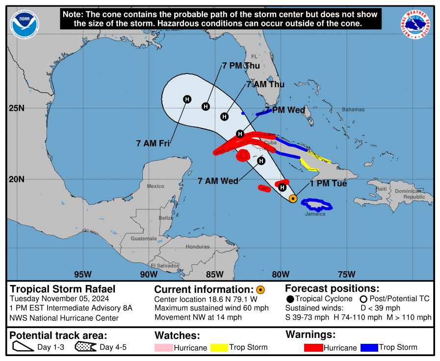
On Tuesday at 12 pm, the National Hurricane Center issued an advisory stating that Tropical Storm Rafael is 70 miles southwest of Montego Bay Jamaica and 150 miles east-southeast of Grand Cayman, with maximum sustained wind of 60 mph. It’s moving at 14 mph to the northwest.
“… the storm is expected to move away from western Jamaica this afternoon, and be near or over the Cayman Islands this evening and tonight, and be near or over western Cuba on Wednesday.” forecasters noted. “Steady to rapid intensification is expected during the next 24 to 36 hours, and Rafael is expected to become a hurricane as it passes near the Cayman Islands with further strengthening before it makes landfall in Cuba.”
YESTERDAY (Tuesday):
Yesterday, the system strengthened into a tropical depression, eventually receiving a name – Tropical Storm Rafael. It later progressed to a tropical storm with sustained winds of 60 mph. Forecasters announced a hurricane warning for western Cuba and isle of youth.
SUMMARY OF WATCHES AND WARNINGS IN EFFECT:
A Hurricane Warning is in effect for:
– Cayman Islands
– Cuban provinces of Pinar del Rio, Artemisa, La Habana, Mayabeque, Matanzas, and the Isle of Youth
A Tropical Storm Warning is in effect for:
– Jamaica
– Cuban provinces of Villa Clara, Cienfuegos, Sancti Spiritus, and Ciego de Avila
– Lower and Middle Florida Keys from Key West to west of the Channel 5 Bridge
– Dry Tortugas
A Tropical Storm Watch is in effect for:
– Cuban provinces of Camaguey and Las Tunas
A Hurricane Warning means that hurricane conditions are expected somewhere within the warning area. A warning is typically issued 36 hours before the anticipated first occurrence of tropical-storm-force winds, conditions that make outside preparations difficult or dangerous. Preparations to protect life and property should be rushed to completion.
A Tropical Storm Warning means that tropical storm conditions are expected somewhere within the warning area.
A Tropical Storm Watch means that tropical storm conditions are possible within the watch area.
Interests elsewhere in Cuba, the Florida Keys, and the southern Florida Peninsula should monitor the progress of Rafael.
HAZARDS AFFECTING LAND:
WIND: Hurricane conditions are expected in the Cayman Islands by this evening and are also expected in western Cuba and the Isle of Youth on Wednesday. Tropical storm conditions are expected in Jamaica for several more hours and are expected in parts of west-central Cuba and the lower and middle Florida Keys on Wednesday and Wednesday night. Tropical Storm conditions are possible farther east in central Cuba on Wednesday.
RAINFALL: Heavy rainfall will impact areas of the Western Caribbean through early Thursday, particularly across Jamaica and the Cayman Islands into southern and western portions of Cuba. Rainfall totals between 3 to 6 inches are expected, with isolated higher totals up to 10 inches anticipated across areas of higher terrain, which could lead to areas of flash flooding and mudslides.
Rainfall totals of 1 to 3 inches are expected for the Lower and Middle Florida Keys.
For a complete depiction of forecast rainfall associated with Tropical Storm Rafael, please see the National Weather Service Storm Total Rainfall Graphic, available at https://www.nhc.noaa.gov/graphics_at3.shtml? Rainqpf
STORM SURGE: Minor coastal flooding is possible in Jamaica tonight. Storm surge could raise water levels by 1 to 3 feet above normal tide levels in the Cayman Islands on Tuesday, and could raise water levels by as much as 6 to 9 feet above normal tide levels in areas of onshore winds along the southern coast of Cuba in the Hurricane Warning area, including the Isle of Youth.
The combination of a storm surge and the tide will cause normally dry areas near the coast to be flooded by rising waters moving inland from the shoreline. The water could reach the following heights above ground somewhere in the indicated areas if the peak surge occurs at the time of high tide…
Dry Tortugas…1-3 ft Lower Florida Keys…1-2 ft
TORNADOES: A few tornadoes are possible Wednesday over the Keys and southwesternmost Florida mainland.
SURF: Swells generated by Rafael are expected to affect much of the western Caribbean during the next few days. These swells are likely to cause life-threatening surf and rip current conditions.
Source: National Hurricane Center


