Tropical Storm Helene: Friday, Sep 27 update from the NHC on latest developments
Published 10:50 am Friday, September 27, 2024

Article first published: Friday, Sep. 27, 2024, 4 a.m. ET
Article last updated: Friday, Sep. 27, 2024, 10 a.m. ET
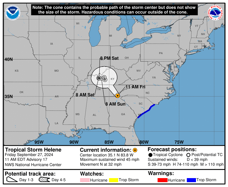
On Friday at 10 am, the National Hurricane Center issued an advisory stating that Helene’s journey: passing Georgia and moving to North Carolina. Helene has lost strength and has downgraded from a Category 1 hurricane to a tropical storm with sustained winds of 70 miles per hour. Tropical Storm Helene is 30 miles southwest of Bryson City North Carolina and 105 miles north-northeast of Atlanta Georgia, with maximum sustained wind of 45 mph. It’s moving 32 mph to the north.
“A slowdown in forward speed is expected soon, and the storm is forecast to stall over the Tennessee Valley tonight and through the weekend.” forecasters explained. “Continued weakening is expected, and Helene is forecast to become extratropical later today.”
Helene passed through Georgia and then headed to North Carolina. With sustained winds of 70 miles per hour, Helene has downgraded from a Category 1 hurricane to a tropical storm.
YESTERDAY (Thursday):
Yesterday, there were a lot of changes, particularly at night: first, Helene changed initially into a Category 2 hurricane, a Category 3 hurricane and a Category 4 hurricane but it ended up as a Category 1 hurricane with sustained winds of 90 miles per hour. Helene first crossed the Gulf of Mexico traveled through Florida and advanced to Georgia
CHANGES WITH THIS ADVISORY:
The Tropical Storm Warning for the Georgia coast has been discontinued.
All Storm Surge Warnings have been discontinued.
SUMMARY OF WATCHES AND WARNINGS IN EFFECT:
A Tropical Storm Warning is in effect for:
– Savannah River northward to Little River Inlet
A Tropical Storm Warning means that tropical storm conditions are expected somewhere within the warning area.
HAZARDS AFFECTING LAND:
STORM SURGE: Water levels will continue to receed along the Florida Gulf Coast and portions of the southeast U.S. coast throughout the day.
WIND: Tropical storm conditions are occurring along much of the South Carolina coast, and these conditions will continue for the next several hours. Strong, damaging winds, especially in gusts,
Will also continue as far inland as the higher terrain of the southern Appalachians.
RAINFALL: Over portions of the Central and Southern Appalachians,
Helene is expected to produce additional rainfall amounts of 3 to 6 inches leading to total rain accumulations of 6 to 12 inches, with isolated totals around 20 inches. This rainfall will result in catastrophic and potentially life-threatening flash and urban flooding, along with significant and record river flooding. Numerous significant landslides are expected in steep terrain across the Southern Appalachians. For a complete depiction of forecast rainfall associated with Tropical Storm Helene, please see the National Weather Service Storm Total Rainfall Graphic, available at hurricanes.gov/graphics_at4.shtml? Rainqpf and the Flash Flood Risk graphic at hurricanes.gov/graphics_at4.shtml? Ero.
For a list of rainfall observations (and wind reports) associated this storm, see the companion storm summary at WBCSCCNS4 with the WMO header ACUS44 KWBC or at the following link: www.wpc.ncep.noaa.gov/discussions/nfdscc4.html
TORNADOES: Tornadoes are possible today across eastern South Carolina, central and eastern North Carolina, and southern Virginia.
SURF: Swells generated by Helene will affect the coasts of Georgia and the Carolinas during the next day or so. These swells are likely to cause life-threatening surf and rip current conditions.
Source: National Hurricane Center


